
Main fires that have been active in Spain until August 22nd
2025 Wildfires in Spain
- With over 362,000 hectares burned, August 2025 becomes the worst August on record in terms of affected area
- With over 405,000 hectares, 2025 is the year with the most burned area since records began
As a practice exercise in research and data analysis for maps, this summer I've dedicated myself (besides resting and relaxing with my family) to researching and updating my knowledge in maps, cartography, code, and data.
As a result, I've created this series of maps to show a summary of the main fires that have been active in Spain until August 22nd. In total, I've created 4 maps that show the scope of the fires, their temporal evolution, and the burned area.
For this, I've mainly used data from EFFIS, Copernicus, and NASA, in addition to data from other media outlets like El País, El Mundo, or RTVE. The programs I've used include QGIS for data filtering and base map design, Illustrator for information layout and final style application, and Photoshop for creating the animated map.
In terms of formats, I've used ai2html for two static maps, html, css, and javascript for the interactive map, and an animated gif for the fire evolution map.
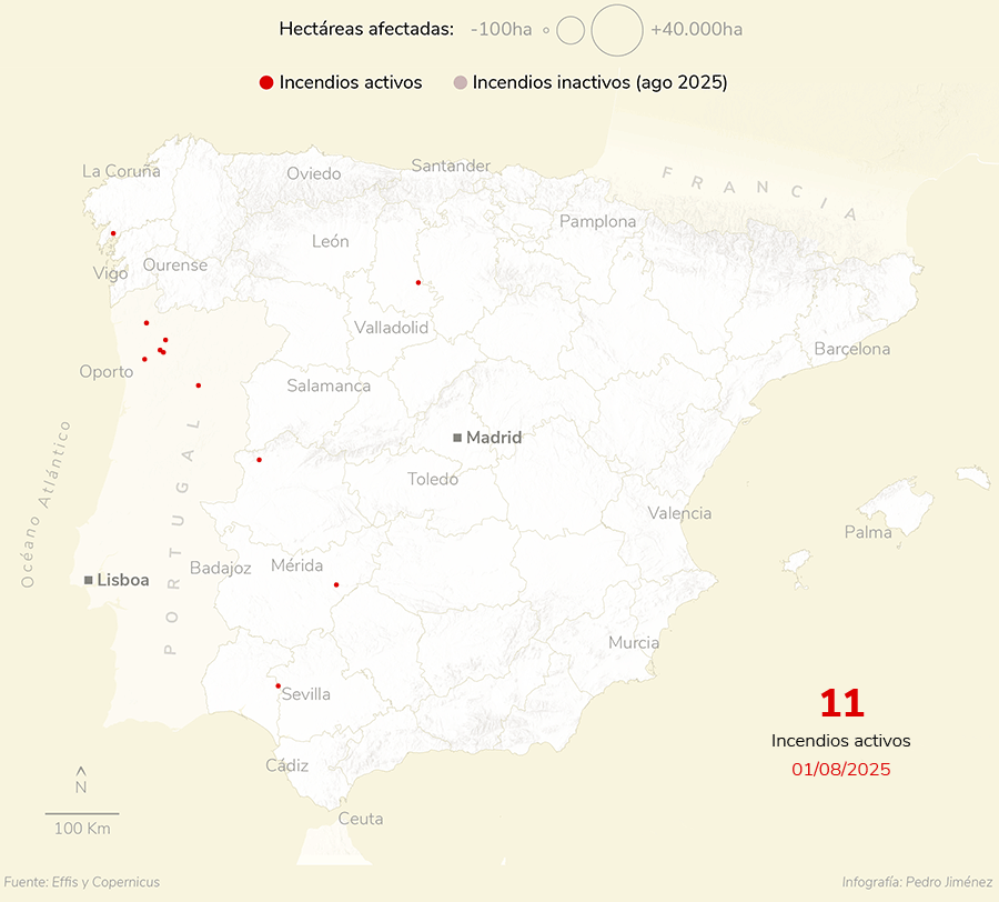
The following animated map shows the evolution of the number of active fires each day in August from the 1st to the 27th, the day I finished collecting data as the critical fire period was coming to an end.
In addition to showing the representative size of each fire's affected area, each day shows an accumulation of already controlled or extinguished fires that occurred in August 2025.
Evolution of the number of fires during August in the Iberian Peninsula
(data from August 1st to 27th)
The following interactive map shows the status of forest fires in Northwest Spain during the month of August. It aims to highlight the most extensive fires and display key information about each one through tooltips to enhance clarity and readability of the map.
And in this last static chart, we can see a closer zoom of one of the main fires in the area, the Larouco fire. The initial idea was to create this type of map for the 4 largest fires, but the truth is that time didn't allow me to do more work on this topic.
In any case, through this first post I wanted to show a series of exercises that I don't usually publish, as they are unpublished pieces. Often we create work that doesn't get published or we do it just to experiment with programs or languages, or simply to practice and improve concepts, as has been the case here.
I'm aware that there are many elements in the tablet or mobile layouts, since in addition to practicing with maps, I've been working on the development of this website where the maps were going to be hosted. I hope that in the future I can add more examples like this of works or projects that have allowed me to learn and improve my skills.